Coordinate Input
Coordinate Input
Everything you can type when GoSurvey asks for a point, a distance, or an angle.
The coordinate frame
| Axis | Survey meaning |
|---|---|
| X | Easting |
| Y | Northing |
| Z | Elevation |
Coordinates you type and coordinates you read are world coordinates — the state-plane or project values, not any internal frame. The status-bar readout, dynamic input, Properties, the Viewpoints table, and every report all show world values.
Large state-plane coordinates are handled at full precision. GoSurvey sets an internal local origin automatically when a drawing first sees big numbers, and does the subtraction in double precision before storing, so an imported CSV point lands exactly on the matching DXF geometry.
Point entry
At any prompt that asks for a point:
| Form | Meaning | Example |
|---|---|---|
| A click | The cursor position, snapped if a snap fires | — |
X,Y |
Absolute world coordinates | 1543268.25,483112.90 |
X Y |
Same, space separated | 1543268.25 483112.90 |
@dx,dy |
Relative to the previous point | @100,0 |
@dx dy |
Same, space separated | @100 0 |
Relative entry is only accepted where a previous point exists to measure from — the second point of
a LINE segment, the destination of a MOVE, the second extension line of a dimension. At a first
point there is no anchor, so @ is refused.
Polar coordinate entry (
@100<45) is not supported. To go a distance along a bearing, use the bearing lock described below.
Z and elevation
Point prompts take X and Y. The Z of new geometry comes from the current work plane, set with
ELEV and shown on the status bar as UCS: World or UCS: Elev <z>. See Drafting Aids.
Angle and bearing entry
North is 0°. Angles increase clockwise.
| Direction | Value |
|---|---|
| North | 0 |
| East | 90 |
| South | 180 |
| West | 270 |
This entry convention is fixed. How angles are displayed — decimal degrees, DMS, or surveyor's
bearings — is a separate setting in UNITS, and changing it does not change what you type.
Accepted formats
| Form | Meaning |
|---|---|
132.5 |
Decimal degrees |
132d30m00s |
Degrees, minutes, seconds |
132d30m |
Degrees and minutes; seconds default to 0 |
132d |
Degrees only |
-45 |
Negative, i.e. counter-clockwise |
Angles are used by LINE and POLYLINE bearing lock, ROTATE, ALIGN, and TEXT rotation.
Bearing lock — distance and direction
The survey way to draw. Available in LINE and POLYLINE after the first point.
| Input | Effect |
|---|---|
A <bearing> |
Lock the direction. A 132d15m30s |
A alone |
Enter bearing-lock mode; type the bearing on the next line. Blank Enter cancels |
A <bearing> +90 |
Bearing plus a turn on one line. -45 works too |
A again |
Clears the lock |
2P (or AP, ANGLEPICK) |
Define the direction by picking two points |
+90 / -45 after a 2P pick |
Adjust the picked direction, then lock |
Enter after a 2P pick |
Lock the picked direction unchanged |
| A number, while locked | Distance along the locked ray. Negative runs backwards |
Example — a traverse leg
LINE
1543268.25,483112.90
A 132d15m30s
248.55
Example — turning off an existing line
LINE
(snap to the start point)
2P                     ← pick two points along the existing line
(click, click)
+90                    ← turn 90° right from that direction, and lock
150                    ← run 150 units
Distance entry
A bare number is interpreted as a distance when the command knows a direction:
- With a bearing locked — distance along the locked ray. A negative value runs the other way.
- With Ortho on and no lock — distance along the horizontal or vertical toward the cursor.
- With neither — there is no direction, so a bare number does nothing useful. Lock a bearing or turn on Ortho.
Distances are in model units, whatever unit your drawing is in. GoSurvey does not convert
units; the UNITS insertion-units setting is a label only.
Dynamic input
While a command expects a coordinate point, two live fields follow the crosshair showing the current world X and Y at the configured display precision.
| Key | Effect |
|---|---|
| Type | Locks the active field to what you type |
| Tab | Moves between the X and Y fields |
| Enter | Commits the point |
| A click in the viewport | Also commits the point |
Prompts that expect a bearing, angle, distance, option, or command name show a single field instead of two.
Display precision and format
Set in the Drawing Units dialog — type UNITS, UN, or DDUNITS.
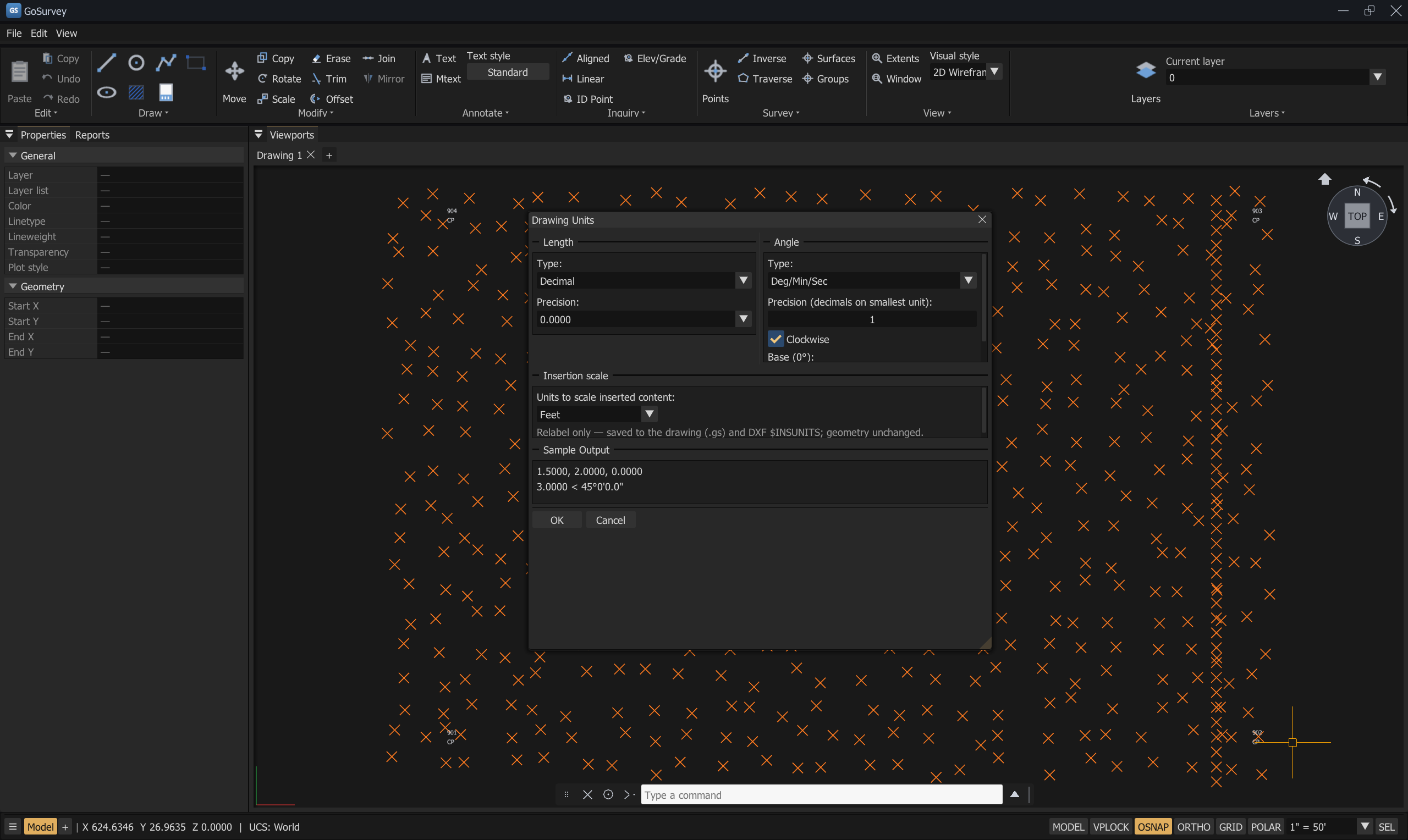
Note the Sample Output box at the bottom: it previews a coordinate and an angle in the formats you have chosen, before you accept them.
| Setting | Controls |
|---|---|
| Length → Precision | Decimal places for coordinates, distances, and lengths across the status bar, Properties, dynamic input, and reports |
| Survey-point precision | An independent decimal count for survey-point coordinates and labels (Settings → Drafting) |
| Angle → Type | Decimal Degrees · Deg/Min/Sec · Surveyor's Units |
| Angle → Precision | Decimals on the smallest unit shown |
| Angle → Base (0°) and Clockwise | The direction base and sense used for display |
| Insertion scale | Feet · Meters · Unitless. A relabel only — written to the .gs file and to DXF $INSUNITS; coordinates are never scaled |
Length Type is fixed at Decimal — GoSurvey works in decimal units, the survey and civil norm.
The other length formats are reserved.
The dialog shows a live Sample Output so you can see the effect before you accept it. Display
precision and angle format are saved as user preferences (gosurvey-user.json); plot scale and
insertion units are stored per drawing.
Coordinate readout
The status bar shows X … Y … Z … for the crosshair, plus the current work plane:
UCS: World— new geometry goes on the world XY plane (Z = 0).UCS: Elev 125.400— new geometry goes at that elevation.
ID reports the coordinates of a picked point into the command log. INVERSE reports ΔE, ΔN,
distance, and bearing between two picks. See Inquiry Commands.
Common problems
| Problem | Cause | Solution |
|---|---|---|
@100,50 is refused |
The prompt has no previous point to measure from | Use absolute X,Y for the first point |
@100<45 does nothing |
Polar entry is not supported | Use A 45 to lock the bearing, then 100 |
| The line went the wrong way | Bearings are clockwise from north, not counter-clockwise from east | 90 is east; 270 is west |
| Typed coordinates land in the wrong place | Typed values are always world coordinates | Check the status-bar readout; if the drawing was imported in local coordinates, use ALIGN |
| The readout shows too few decimals | Display precision | UNITS → Length → Precision |
Related
Object Snaps · Drafting Aids · Drawing Tools · Inquiry Commands · Settings and Options